Missoula Floods sculpted Pacific Northwest, Columbia
Published 4:00 pm Thursday, March 6, 2014
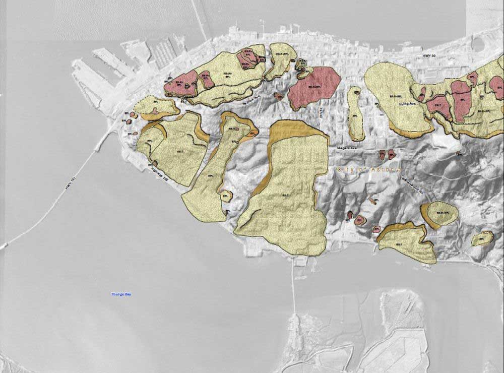
- <p>About 120 landslides have hit the Astoria hillsides. The beige includes prehistoric landslides more than 150 years old, while those still active or within the last 150 years are in red. The uppermost surface of ruptures in the slides are in orange.</p>
Establishment geologists in the 1920s believed that gradual changes swept over the Columbia River Basin, slowly sculpting its landscape. But geologist J. Harlen Bretz had a more cataclysmic hypothesis: the Missoula Floods.
Trending
A series of about 40 cataclysmic flash floods emanating from Western Montana gushed across Eastern Washington and down the basin at more than 1,000 times the power of the modern-day Columbia River, sculpting much of its modern landscape all the way to the Pacific Ocean.
Engineering geologist Bill Burns and cartographer and Geographic Information System Technician Dan Coe of the Oregon Department of Geology and Mineral Industries took the crowd at Thursdays Columbia Forum through the Missoula Floods and into the danger of landslides along most of Astorias hillsides.
Glacial Lake Missoula, the source of the floods, formed during the last Ice Age after a finger of the Cordilleran ice sheet moved south and blocked the Clark Fork River with a 2,000-foot frozen dam. It created behind it an inland sea stretching 200 miles east at some points.
Trending
Between 15,000 and 18,000 years ago, said Coe, the dam would fail an average of once every 50 years. Up to 500 cubic miles of water and ice, according to the U.S. Geological Survey, could empty in as little as 48 hours.
It washed down Eastern and Central Washington, the Columbia River Gorge, Willamette Valley and lower Columbia at 10 times the combined rate of all the worlds rivers combined. Coe said it could take anywhere from a few days to a couple weeks for each flood to finish.
Im sure it was much more like a debris slurry, said Coe about the water, rocks and ice chunks brought down the basin at upward of 65 miles per hour, shaking the ground on their approach to the ocean. The floods could raise the water level up 850 feet in the gorge and 400 feet in the Portland basin, flooding down the Willamette Valley and down the Columbia.
This is quite a deep canyon, said Coe, who estimated the depth of the pre-Missoula Flood Columbia at 350 to 400 feet deep underneath the Astoria Bridge. The Ice Age coastline was 40 miles further out.
In Astoria, it (the flood) was at about modern-day sea levels, which doesnt sound like a lot, but when you talk about the 350-foot deep gorge, theres still very deep river water that flowed out into the ocean and dropped its sediment.
The floods took out all but the most hardy rocks, including old volcano cores such as Beacon Rock in the Gorge and Rocky Butte near Portland.
First Bretz, then Lidar
Planes were just coming about in the 1920s when Bretz was researching the hypothesis of the Missoula Floods, said Burns, and the earlier scientist could afford to fly around.
He was kind of like an ant wandering around the landscapes, especially over in Eastern Washington, trying to figure out what these huge-scale features meant, said Burns of Bretz. He later coined the term channeled scablands to describe the area around Grand Coulee Dam, where floods had cut through basalt deposits.
It was a 40-year debate for Bretzs Missoula Floods hypothesis to be fully vindicated near the end of his life, and the events are sometimes called the Bretz Floods in his honor.
In contrast, Coe and Burns have studied the floods and the regions topography for DOGAMI largely from the air using advanced remote sensing technology called Lidar, in development since the 1960s, but, said Coe, only flown in the region for about 10 years. The technology has allowed them to drastically increase the resolution of topography resulting from the Missoula Floods.
Its basically lots and lots in fact millions of measurements made with a laser range finder, said Burns, in front of a detailed 3-D image of Astoria, down to tree branches and a car on the Astoria Bridge. In their research, Burns and Coe attached a Lidar unit that shot lasers 100,000 to 200,000 times per second from the bottom of a plane to the ground, analyzing the reflected light.
Landslide city
Anybody familiar with the hills of Astoria knows about landslides. Burns, who along with Coe has studied Astorias landslide history and risk, pointed to water, steep hill grades and looser geology as the three main factors behind landslides. And rainy Little San Francisco has all three going for it.
This whole area is a landslide zone, said Burns, pointing along a map on the northern and southern slopes of the city. The Missoula Floods, he added, helped with the landslide-prone geological makeup.
About 120 landslides, he said, have struck Astoria, 83 within the last 150 years. From 1937 to 2007, there were 17 recorded landslides, including one in 1950 that destroyed 23 homes and the latest series, still visible near West Bond and Commercial streets seven years after.
The other thing we found is that a high percentage of the city 55 percent is susceptible to shallow landslides in the future, and a rather high percentage of areas susceptible to deep landslides 37 percent, said Burns, adding that a lot of them have been precipitation-triggered and are on top of previous landslides
When looking at how earthquakes might affect landslides in Astoria, Burns said he and Coe ran scenarios combining the two.
When we ran it for the crustal earthquake, it was about 12 percent of the total of all the stuff that is here in the city, said Burns. When we ran that with the landslides, it went up to around 21 percent.
That means that all the damage that were already imagining is going to happen from that shaking, actually were going to have about twice as much damage thats going to occur just from those landslides that are going to move in that earthquake.
The damage, said Burns, could total $800 million, or about 28 percent of all the stuff in Astoria, with a combination of a Cascadia Subduction Zone and resulting landslides.
What to do
If one were sort of curious to see if ones house were likely to be washed away, posed David Oser, stalled momentarily by a flood of laughter, where would one look?
DOGAMI has created such resources as the Statewide Landslide Information Database for Oregon, located at http://www.oregongeology.org/sub/slido/index.htm or on CD from the agency.
Most city officials are aware that there are hazards here, said Burns, adding that the maps they create help people learn where to control storm water, where not to excavate, in general how to handle their property in a slide zone.
We recently published, which you might have heard of, the tsunami inundation maps and landslide hazard maps, said Coe. And were actually working on flood insurance rate maps for Clatsop County as well. So were covering this area pretty well, so give us a call.
Marketplace


-
eEdition

-

-
