From the editor’s desk
Published 8:00 am Saturday, May 25, 2024
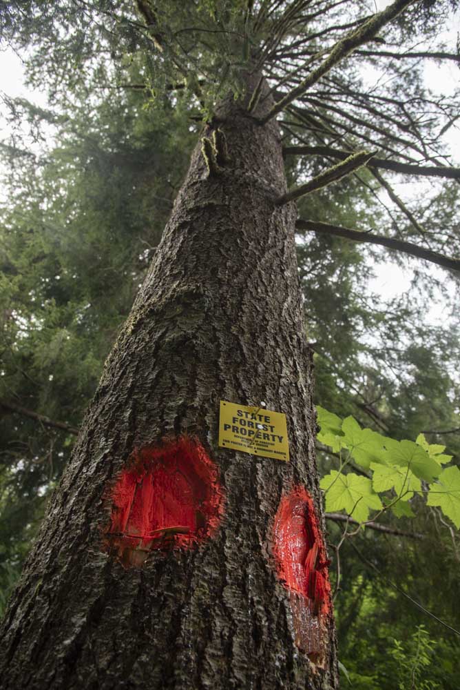
- A large tree on Darren Orange’s property is marked by the Oregon Department of Forestry.
Thank you for your interest in reading The Astorian. Here are a few stories that you might have missed this week:
•••
When Darren Orange received a letter from a surveying company in late March, he never expected it might lead to a clearcut next to his backyard.
Like many people living next to state forestland, Orange knew there was always a possibility the stands near his home east of Astoria might be managed or thinned — but a few weeks ago, he watched as crews marked the trees along his property line with fluorescent orange spray paint and neon pink flags. A section of forest behind that line, he learned, had been slated for a timber harvest.
“Most of us bought homes here with the idea that being a forest that this would be here as long as we were here,” Orange, a painter, said. “We’re realizing now due to the state’s revenue concerns that that’s not always the case.”
The site near Orange’s property, known as Mothball Hill, is one of several clearcut timber operations proposed in the Oregon Department of Forestry’s Astoria District Office annual operations plan. The plan itself is nothing out of the ordinary — as the name suggests, the district publishes one every year. This year’s response from the public, however, is.
In the final days leading up to the plan’s public comment deadline last week, two proposed harvests have drawn the attention of neighbors, and about half a dozen people spoke out at a Clatsop County Board of Commissioners meeting on Wednesday night.
“Typically, the only feedback we get during that public outreach process is usually from the environmental stakeholders and the industrial stakeholders,” Astoria District Forester Dan Goody said. “We very rarely get local folks chiming in.”
See the story by Olivia Palmer by clicking here.
•••
The Astoria City Council voted on Monday night to approve a memorandum of understanding with the Clatsop County Historical Society, allocating $300,000 over three years toward the expansion of the Oregon Film Museum.
The historical society plans to construct a two-story, 13,000 square foot building located at Seventh and Duane streets, an approximately $10 million project that will include a 50-seat theater, a projection room, classroom space, an expanded gift shop and several new exhibits.
McAndrew Burns, the historical society’s executive director, presented the plans at a City Council work session in March and explained that the museum has outgrown its footprint at the old county jail, an 800 square foot building.
At that work session, Burns proposed that the City Council show its support for the project with a $300,000 commitment from the city’s Promote Astoria Fund. On Monday, the council agreed to support the project, but left the terms of the memorandum vague so the funding could come from a variety of sources, including the general fund.
Read the story by Rebecca Norden-Bright by clicking here.
•••
Community leaders in Clatsop County are taking stock of new draft flood risk maps presented by the Federal Emergency Management Agency.
Although the maps are still in the early stages, initial data indicates they could have significant impacts on Warrenton.
The maps are intended to give a snapshot in time of flood risks. FEMA began its Risk Mapping, Assessment and Planning program in 2009 and released its first map for Clatsop County under the program in 2010. The new draft maps provide updated modeling for areas between Hammond and Tongue Point, including new Special Flood Hazard Areas, or areas with a 1% annual chance of flooding in any given year.
Based on changes to the Special Flood Hazard Areas, FEMA anticipates adding an estimated net total of three structures to the flood plain in Astoria, four structures to the flood plain in the unincorporated county and 1,026 structures to the flood plain in Warrenton. Structures include homes, sheds and gazebos.
FEMA Region 10 engineer Dale Meck said one reason for the update is that risk naturally changes over time, especially along rivers. Another is that FEMA now has more accurate tools and data for geospatial modeling.
The draft maps are about a year out from preliminary release, and even further out from adoption — but presentations to community leaders provide an initial opportunity for feedback based on their knowledge of the area and history of natural hazard risks.
“We use it as a really good local gut check of the models,” Meck said. “Let’s get input, let’s make sure community leaders buy in before we gear up for a full public outreach.”
Take a look at the report by Olivia Palmer by clicking here.
•••
We invite you to help sustain local journalism on the North Coast. Please consider subscribing. We have several options available at: www.dailyastorian.com/subscribe-now/
— Derrick DePledge

-
eEdition

-

-

