OSU report identifies Seaside’s Cascadia risk
Published 4:11 am Wednesday, June 13, 2018
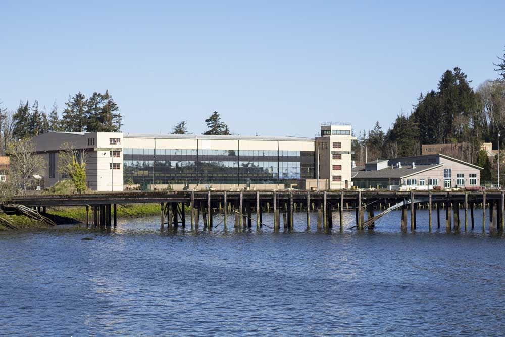
- One of the bridges over 12th Street in Seaside is an example of infrastructure in the area that could fail in an earthquake.
A new computer simulation by Oregon State University identifies bridges and roads in Seaside that would have the highest mortality rates in an earthquake and tsunami.
The bridge on Broadway Street over Neawanna Creek would result in the most fatalities and should be prioritized for improvement, researchers found. Other critical locations at the two bridges on 12th Street, the bridge on Sundquist Road and Ocean Vista Drive in the Cove were also flagged.
“The real issue with Broadway is there is really nowhere else to go, but by the time you get to that bridge you have very little time to do anything else,” said Dan Cox, an Oregon State civil engineer who created the model with Haizhong Wang. “It’s a combination of what options you have and how much time you have to do it.”
The bridges and roads are high priorities to retrofit not because of structural integrity issues or age — metrics most often considered when replacing city infrastructure. The mortality rate spikes because of relative proximity to areas where people live and gather, making them some of the most populated evacuation routes. They also fall in the path of where tsunami inundation will most likely occur.
Thousands of scenarios were run through the model based on the starting points of 4,500 imaginary people, distributed to resemble where most people would be on a busy, summer day: on the beach and shopping downtown.
“As engineers, we’re interested in infrastructure and what can be done to have more lives saved,” Cox said.
The goal was to provide Seaside a simulation that would support evidence-driven decision-making when it comes to addressing the city’s infrastructure needs, Wong said. Without assigning specific dollar amounts, researchers also simulated how the mortality rate might change depending on how many resources were allocated to what structure to make it more likely to withstand an earthquake.
They found that the bridge on Broadway should have the highest priority for retrofitting due to the fact it was the most traversed bridge in their simulation. The study also recommended investing resources in building highly resistant vertical structures inside the inundation zone as a more economical choice than spending greater amounts of resources on retrofitting multiple bridges.
“After a certain point, your return on investment might not be to fix more bridges, but take those resources and put it toward a vertical evacuation structure,” Cox said. “It might not even be infrastructure. You could possibly use resources in more education, et cetera.”
The integrity of Seaside’s bridges during a seismic event is not a new concern. In 2015, Transportation for America, a Washington, D.C.-based infrastructure advocacy group, found seven of 10 bridges in Seaside were “structurally deficient.”
But the conversation has mostly focused around structural deficiencies rather than population distribution, and the timing of the new study could possibly influence the outcome of a work session scheduled in July centered around designing a strategy for bridge replacement.
City Councilor Tom Horning, a geologist who will lead the discussion, has been an advocate for replacing bridges at Avenue U and Avenue G in particular. He wants to make sure areas on the south end of town with evacuation times estimated at 35 minutes will have a reliable and quick way out to high ground.
But his ultimate goal is to persuade the city to develop a plan that retrofits every bridge.
“Seaside, because of geographic layout and rivers, is one of the most challenging communities on the coast,” Horning said, in reference to evacuating in a tsunami. “There’s a strategy in focusing on population concentrations and prioritizing based on that. But every bridge needs to be done. We don’t want to find ourselves in a Hurricane Katrina situation, where we knew there was something that could be done but didn’t do it.”
Horning said the city should consider more than just the computer simulation.
“I think the OSU modelers have done a nice job with their models, but their conclusions need to be considered along with other issues,” Horning, a geologist, said. “I think they are valuing the population densities too aggressively.”
While Horning agrees the Broadway Bridge and 12th Avenue structures are heavily trafficked, these bridges happen to be ones that will fare “quite nicely” in the event of an earthquake, he believes, and that it is all the other bridges in town that could fail.
“I agree that the East Broadway and the 12th Avenue structures are important lifelines, but they ought to be regarded as capable of withstanding the next quake and they should be lauded as great examples of good bridges,” Horning said in an email.
Oregon State civil engineer Dan Cox said he did not want give the impression that the bridges were not good in this study since the team did not do any structural engineering analysis.
“The main focus of our study was to understand what were the most important bridges for evacuation,” Cox said.
Cox and Wang emphasized their research — funded by the Oregon Sea Grant and the National Science Foundation — is not an end-all solution for tsunami preparations in Seaside, and that they hoped their findings would be a “piece of the puzzle.”
The two are working on a new study on the most effective locations for vertical evacuation structures in Seaside, of which there are many, preliminary research shows. They are also working on new simulations that account for a tourist population who may not know the most efficient route to high ground, different weather conditions and different times of day — all factors that change human behavior and could provide new recommendations.