Where are you, Mishawaka?
Published 7:00 pm Thursday, January 25, 2018
- notforsale
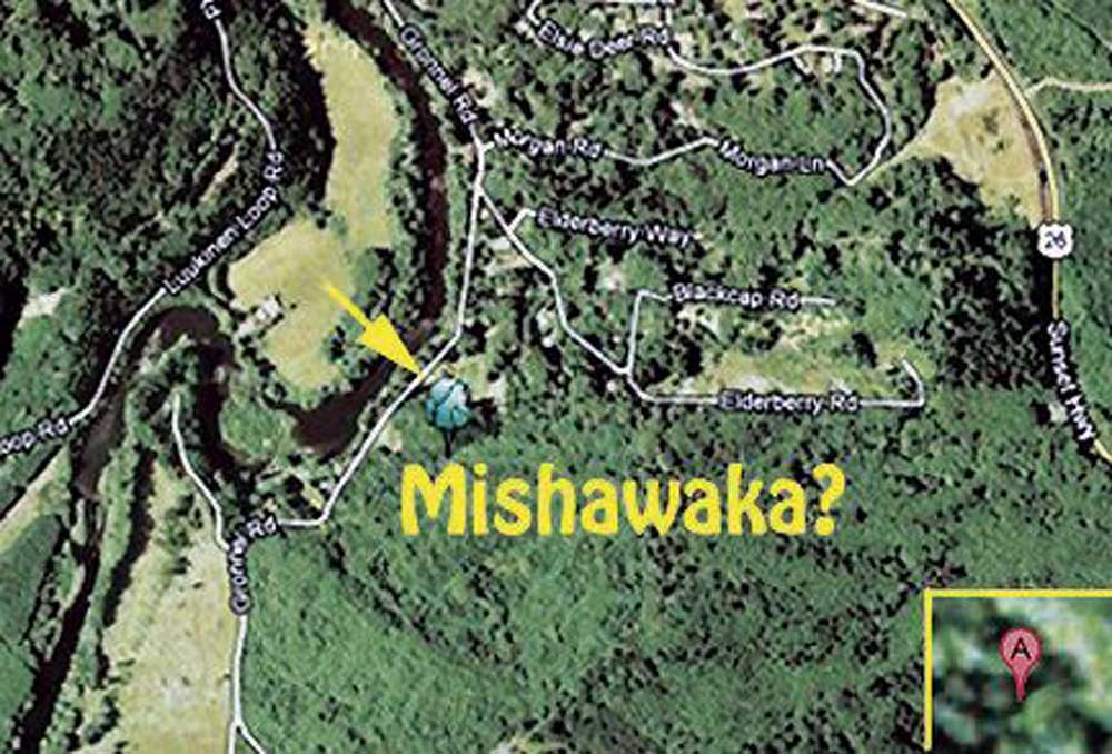
Fun rerun, first ran Jan. 27, 2012: Where is Mishawaka? Inquiring minds wanted to know, so Mr. Google was consulted. A historic post office was mentioned, along with a map showing the location, which appears to be near Elsie, off Gronnell Road.
Trending
Close-up, Mr. Google thinks the Mishawaka post office is a tree (see photo inset). Not helpful. The U.S. Geological Survey Geographic Names Information System refers to Mishawaka as a “populated place,” which means scattered buildings and human population in an area with no legal boundaries. Also not very helpful.
The Ear finally turned to Liisa Penner at the Clatsop County Historical Society to find out the real story.
“Mishawaka was a farming community,” Liisa wrote in reply. “J.S. Dellinger’s 1896 Astoria City Directory lists 40 men there, all farmers except for one carpenter (G. W. Miller) and one blacksmith (A. J. Adams). Names of women and children were omitted, but all together made a sizable number of people in the area.
Trending
“Mishawaka was primarily a name for a post office in the home or store of one of the residents, where people in the area could pick up their mail. The 1888 Oregon State Gazetteer describes it this way:
“‘Mishawaka. A country post office on the Nehalem river in Clatsop County, 38 miles southeast of Astoria, the county seat and bank location, and 20 miles south of Olney, its shipping point, by water. It contains a water power flour mill. Population, 25. Mail, weekly. J.J. Lynch, postmaster and farmer.’”
Just of few of the other distinguished residents were the justice of the peace, H.W. Birchard, a fruit grower, A. Furtado, and the flour mill owner, E.L. Jones.
“Astor Anderson, the constable,” Liisa noted, “later spent time in the penitentiary for embezzling funds from the post office, which proves that not all the interesting people in the county were from Astoria.”
Marketplace


-
eEdition

-

-
